Evidence for Continental Drift — Print · Grade 9 Science
Chapter: Earth’s Interior & Plate TectonicsEvidence for Continental Drift
Learning goals
- I can describe Alfred Wegener's continental drift hypothesis and the supercontinent Pangaea.
- I can explain how matching fossils, rock layers, continental shapes, and climate evidence support continental drift.
- I can explain how seafloor spreading and paleomagnetism finally gave continental drift a mechanism.
Readings for this unit
Before this unit
Compare independent lines of evidence.
Plan three teaching sessions: core explanation and Parts 1–2; Parts 3–4 with diagrams and reasoning checks; then the whole-unit application, worked examples, independent practice, and exit check. Read one part at a time, explain it without notes, and revisit any gap. Allow about 40–50 minutes per session; adjust after checking understanding. Trace and explain the labeled figures in each part. In the third session, complete the illustrated case and changed independent application; retain a corrected explanation rather than only an answer.
Start with something to explain
What makes continental drift stronger than a puzzle-piece guess?
Illustrative evidence case. Separated regions contain matching fossil groups in comparable-age strata. A ridge has young crust near its center and older crust farther away.
Notice and wonder
Record two observations using the stated quantities or relationships. Keep observations separate from possible causes. Write one question that a new measurement could help answer.
What makes continental drift stronger than a puzzle-piece guess?
Your first model
Draw a proposed past connection and list independent patterns it should explain.
Build the language from the idea
- continental drift
- Alfred Wegener's idea that continents were once joined together and have since slowly moved to their current positions.
- Pangaea
- The single supercontinent that Wegener proposed all of today's continents were once joined together as, before it broke apart.
- seafloor spreading
- The process by which new ocean floor forms at mid-ocean ridges and spreads outward in both directions, providing the mechanism for continental drift.
- paleomagnetism
- Magnetic patterns frozen into ocean-floor rock as it cooled, recording the direction of Earth's magnetic field at the time — used as evidence for seafloor spreading.
In 1912, a German scientist named Alfred Wegener pointed out something that feels obvious once someone shows you: the eastern coastline of South America and the western coastline of Africa look like they'd click together, like two pieces torn from the same puzzle. Wegener proposed that all of today's continents were once joined into a single gigantic supercontinent he named Pangaea (Greek for 'all land'), which later broke apart, its pieces slowly drifting to the positions we see on the map today. That idea — continents wandering across the globe over vast stretches of time — became known as continental drift.
A coastline hunch isn't proof, so Wegener piled up evidence. Identical fossils of the same land and freshwater species — the reptile *Mesosaurus*, the fern-like plant *Glossopteris* — show up on continents now separated by thousands of kilometers of open ocean, even though neither creature could possibly have swum or floated across. Whole mountain ranges match up too: the Appalachians of eastern North America line up with ranges in Scotland and Scandinavia as if a single belt of folded rock had been torn in half and the halves floated apart.
Ancient glacial deposits and striations in presently warm regions can constrain past positions and conditions. Coal-bearing deposits also record past environments favorable for organic accumulation and preservation, but coal does not form only in tropical climates. Interpret these indicators with dated rocks, regional geology and other evidence; present latitude alone does not describe the entire history.
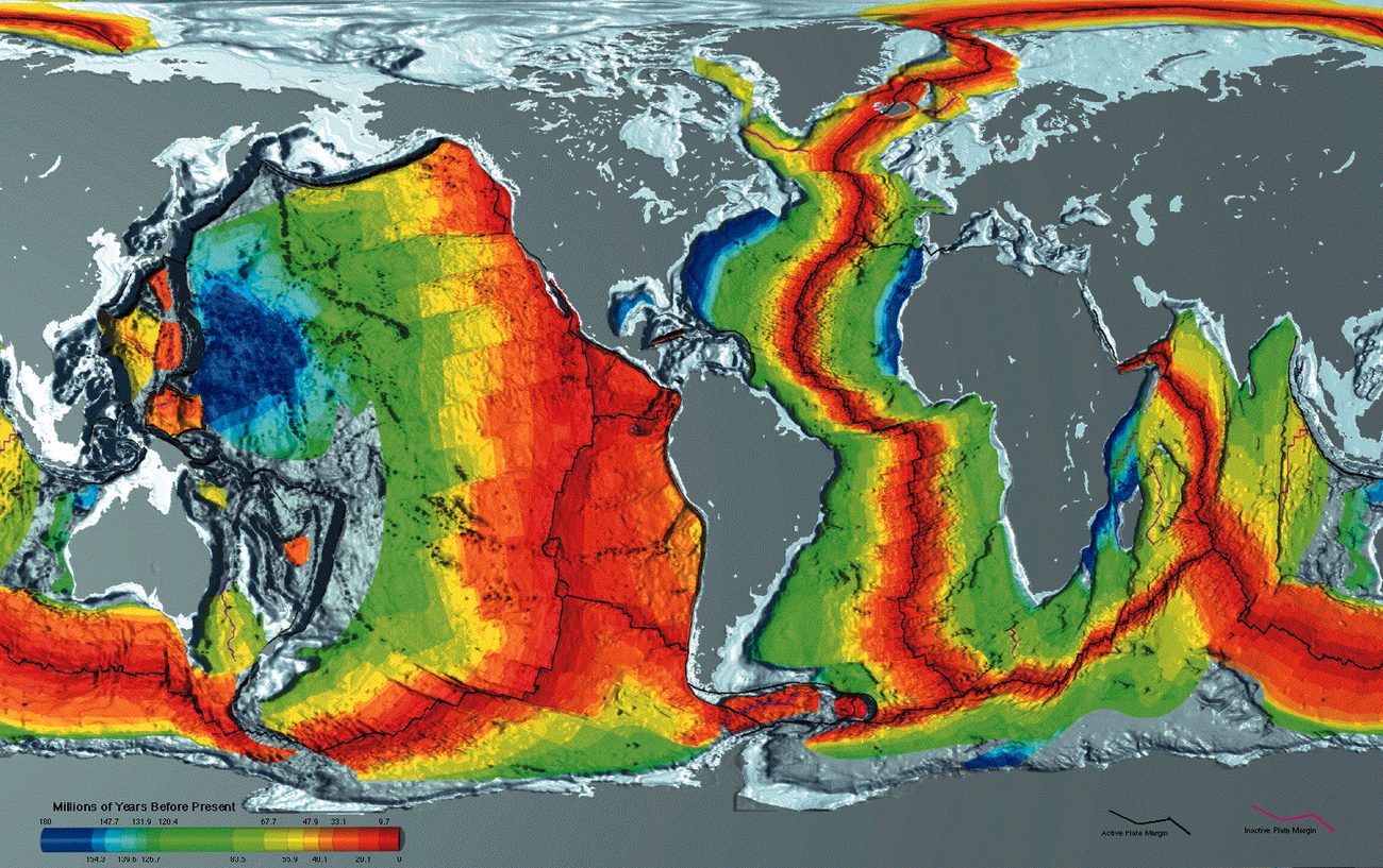
Despite the mountain of evidence, most scientists dismissed Wegener's idea for nearly fifty years — and for a fair reason: he couldn't explain *how* something as colossal as a continent could possibly plow through solid ocean floor. That missing piece is a great lesson in how science works, because a hypothesis usually isn't accepted until someone can show a believable mechanism. The mechanism finally turned up in the 1960s with the discovery of seafloor spreading — the process by which fresh ocean crust is born at mid-ocean ridges and spreads outward in both directions, like a slow conveyor belt carrying the continents along rather than dragging them through solid rock.
The proof of seafloor spreading came from paleomagnetism. As new ocean floor cools at a ridge, iron-bearing minerals in it freeze into place pointing toward Earth's magnetic field — and because that field flips direction every so often over geologic time, the seafloor recorded the reversals as a pattern of magnetic stripes, laid down in a perfectly matching mirror image on both sides of the ridge. That symmetry could only mean the floor was spreading outward from the center. With a real mechanism finally in hand, continental drift was absorbed into the powerful modern theory of plate tectonics — a reminder that even an idea scientists once laughed at can turn out to be right, once the evidence and a mechanism line up. Modern satellite instruments can now detect the plates still creeping along, confirming Wegener's once-ridiculed vision in numbers he could never have gathered himself.
Matching coastlines are suggestive, but continental margins and their shapes change through time. Fossils, matching rock belts and past-climate indicators across separated continents provide stronger combined evidence for former connections.
Seafloor spreading added evidence that the earlier continental-drift model lacked. Symmetric magnetic patterns and increasingly old ocean-floor rocks away from ridges support creation and movement of crust. A model gains strength when it explains independent observations with one mechanism.
Compare alternative explanations and the distribution of evidence. Similar fossils could sometimes reflect dispersal, but matching ancient land organisms, rock structures and glacial traces together demand an explanation. Historical scientific models changed when new measurements resolved earlier weaknesses.
Build your understanding
Plan three teaching sessions: core explanation and Parts 1–2; Parts 3–4 with diagrams and reasoning checks; then the whole-unit application, worked examples, independent practice, and exit check. Read one part at a time, explain it without notes, and revisit any gap. Allow about 40–50 minutes per session; adjust after checking understanding.
Part 1 · A hypothesis with multiple predictions
Continental drift describes the idea that continents changed their positions through time. Matching outlines suggested a reconstruction, but coastlines can change as sea level, erosion and sediment alter the shoreline. Comparing continental-shelf margins can provide a different geometric constraint. A hypothesis gains strength when it predicts independent patterns: rock ages, mountain belts, fossils and past-climate indicators should also agree when the proposed pieces are placed together. Attractive puzzle shapes alone do not supply the force or mechanism that moved them.
Read the visual model
The shapes are intentionally invented margin outlines. Their apparent fit suggests a comparison to test, rather than identifying actual continents.
What independent evidence would strengthen a proposed fit beyond outline similarity?
Visual reasoning — after your attempt
Matching dated rock sequences, mountain belts, fossil distributions with suitable ages/ecology and past-climate indicators can test the reconstruction. Modern motion measurements supply a further, different test.
Continental drift proposed that continents had changed position. Matching continental outlines suggested a question, but evidence included rock belts, fossil distributions and past-climate indicators. A strong hypothesis predicts several independent patterns; a visually appealing coastline fit alone is not a full test.
Compare continental shelves rather than modern beaches when evaluating a fit, because erosion and sea-level changes affect coastlines. Identify which features are measured and which former arrangement is inferred.
Pause and explain
Why is a shelf-edge comparison useful beyond the present shoreline?
Check your reasoning after answering
Present shorelines change with sea level and erosion; shelf geometry provides a different constraint on a proposed fit.
Part 2 · Fossils, rocks and climate indicators
A fossil distribution is more informative when the organisms’ habitats and the containing rocks’ ages are known. The same freshwater or terrestrial organism in comparably old strata on separated landmasses can challenge an explanation requiring it to cross a wide ocean. But similar appearance alone can lead to mistaken identification, and transport, dispersal or environmental differences may provide alternatives. Combine the fossil pattern with dated rocks and other indicators before proposing former connection. A fossil establishes a preserved occurrence, not a map of every place the organism once lived.
Read the visual model
Use the matching fossil symbols as one evidence layer. The supplied age relationship is crucial; the circles are tracking labels rather than real fossil drawings.
Would two matching-looking specimens from very different geological ages provide the same connection evidence?
Visual reasoning — after your attempt
No. Their identification, age ranges and ecology must be checked. Very different ages can reflect separate occurrences rather than the proposed simultaneous connected habitat.
Matching fossils in separated regions can support formerly connected habitats when organism ecology and rock ages are consistent. Mountain belts and rock sequences can add independent constraints. Glacial deposits record past conditions; their significance depends on reconstructing locations and comparing competing explanations.
One shared fossil does not prove every continent was joined at one time. Specify age, distribution, likely dispersal and the other evidence; several converging lines strengthen the reconstruction.
Pause and explain
What extra information makes a matching fossil distribution more informative?
Check your reasoning after answering
Comparable age, ecology/dispersal limits and consistent rock or geographic evidence.
Part 3 · Seafloor evidence supplies a mechanism test
Some iron-bearing minerals align with Earth’s magnetic field as molten rock cools. Once sufficiently cool, that magnetic remanence can preserve the field direction at formation. Field reversals over time therefore create alternating records as new crust forms near a ridge. Opposite sides can contain corresponding age and polarity sequences as they spread apart. These magnetic stripes are records of past conditions; they are not giant striped magnets driving the plates. Unequal spreading or later deformation can modify ideal symmetry.
Read the visual model
Start at the ridge and compare successive bands moving outward on both sides. Color represents polarity record, not the literal visible color of ocean crust.
What two independent measurements would help test the spreading interpretation?
Visual reasoning — after your attempt
Compare dated crust ages with distance from the ridge and measure magnetic polarity patterns. Agreement of age trend and corresponding bands supports the model more than either alone.
Seafloor spreading connected new crust at ridges with older crust away from them. Alternating magnetic polarity bands can record field reversals as rock cools. Paired patterns and age trends support spreading; magnetic stripes are records of past fields, not giant magnets pulling continents apart.
If the same sequence occurs on both sides of a ridge, compare width and age as well as the polarity pattern. Unequal rates can complicate perfect visual symmetry without eliminating the underlying mechanism.
Pause and explain
What do magnetic stripes record, and what do they not directly cause?
Check your reasoning after answering
They record field polarity at cooling; they do not supply the force moving plates.
Part 4 · Scientific revision and present-day tests
Geodesy measures Earth’s shape, positions and movements. Repeated satellite-based position estimates can track station displacement over years. A supplied 10 cm eastward change in four years corresponds to 2.5 cm/year in the chosen reference frame. Extrapolating this rate through millions of years requires an assumption that direction and speed stayed unchanged, which may fail. Plate tectonics extended drift by connecting independent records to spreading, subduction and lithospheric motion. Scientific revision retains successful evidence while improving mechanisms and predictions.
Read the visual model
Read eastward displacement from an initial reference position. The curve is a selected constant-rate record, not a claim that every plate moves east.
Why can this four-year graph not determine the station’s location 100 million years ago by itself?
Visual reasoning — after your attempt
Rate and direction can change, and the station’s plate history may include deformation or boundary changes. Ancient positions require geological and paleomagnetic constraints as well as models.
A useful idea can explain some observations while lacking a satisfactory mechanism. Plate tectonics incorporated drift into a broader account of lithospheric motion, spreading and subduction. Modern measurements can test present movement, while geological evidence reconstructs past arrangements.
State what changed between the early drift proposal and plate tectonics. Scientific development involves new evidence and improved mechanisms, not only acceptance of a previously ignored conclusion.
Pause and explain
Why does evidence for present plate motion not determine every ancient position by itself?
Check your reasoning after answering
Past reconstruction also needs dated geological records and assumptions about how motion changed through time.
Apply the whole unit · Build a converging-evidence argument
Illustrative packet: two separated margins share dated rock belts and fossil assemblages; an intervening ridge has paired magnetic patterns and progressively older crust outward.
Your task
Construct an argument linking past connection and later spreading. Distinguish each observation from its inference and state a competing explanation that additional data could test.
What your response should show
- Use the supplied evidence accurately and label units or locations.
- Explain a physical mechanism or evidence-to-claim relationship.
- Show calculations or a clearly labeled model when the task calls for one.
- Identify a meaningful assumption, uncertainty, or competing explanation.
Response guidance — after your attempt
The margins’ dated matches support connection; seafloor records support subsequent spreading. Together they constrain a mechanism better than shape alone. Test ages, rock continuity and independent movement measurements; avoid assigning exact past positions without a reconstruction.
Scientific references and adapted source material
Parent / teacher teaching notes
Ask the learner to explain the force versus record distinction. Mark how evidence lines fit together, rather than reward a list of Wegener facts alone. Ask the learner to explain each visual label and causal step before calculating. Preserve a first model, attempt the changed independent case, then use feedback to revise. Diagrams state whether values are illustrative or observed. Selected OpenSciEd excerpts are middle-school source material used for supported foundations; the independent high-school explanations and supplements are not the complete OpenSciEd teacher editions or an endorsement.
The key idea
Matching fossils, rocks, coastlines, and climate clues showed that continents were once joined as Pangaea, and seafloor spreading later supplied the missing mechanism for how they drift apart.
Worked examples
Example 1
- Mesosaurus was a small freshwater reptile — it could not have swum across a vast, deep, salty ocean.
- Since the same fossil appears on both continents, those two landmasses must have been connected (or very close together) when Mesosaurus was alive.
- This supports continental drift: South America and Africa were once joined as part of Pangaea and have since drifted apart.
Example 2 · Worked application
- Shared fossils can support former connection when ages and organisms match.
- Matching rock belts or magnetic seafloor patterns provide independent evidence.
Similar appearance alone is weaker than dated, identified specimens.
Example 3
- Mountain ranges form as continuous belts of folded rock — if the pattern matches perfectly, the rock was likely folded as one continuous range.
- North America, Scotland, and Scandinavia are now separated by the Atlantic Ocean, so they cannot have formed this shared mountain belt in their current positions.
- This is best explained if these landmasses were once joined together (as part of Pangaea) when the mountain range originally formed, and later drifted apart, splitting the range between continents.
Example 4
- New crust can form at the ridge.
- As plates separate, older crust moves away symmetrically.
Example 5 · Find and fix the mistake
- Test the claim against the stated conditions: Similar appearance alone is weaker than dated, identified specimens.
- The fit is one clue; fossil, rock and seafloor evidence test the history and mechanism.
Similar appearance alone is weaker than dated, identified specimens.
Example 6 · Reason from the visual evidence
- Start at the ridge and compare successive bands moving outward on both sides. Color represents polarity record, not the literal visible color of ocean crust.
- Compare dated crust ages with distance from the ridge and measure magnetic polarity patterns. Agreement of age trend and corresponding bands supports the model more than either alone.
Original idealized magnetic-band model shows paired polarity records and an age trend away from a spreading center. Band widths are simplified and do not supply actual reversal durations. The central line is the ridge; stripes symbolize mineral records rather than physical forces.
Avoid these mistakes
- Matching coastlines alone are not the complete evidence for plate tectonics.
Check your understanding
Ocean-floor rocks are youngest at a ridge and older on both sides. What explanation fits?
Discuss the answer
Seafloor spreading fits the age pattern; magnetic stripes and plate-motion data provide additional tests.
Why are multiple independent kinds of evidence stronger than one suggestive match?
Discuss the answer
Independent fossil, rock, age, magnetic and motion records constrain different predictions and alternatives. Agreement across them is harder to explain as one accidental outline similarity.
Return to the phenomenon
Return to the initial case. What makes continental drift stronger than a puzzle-piece guess? Revise your drawing or explanation using two named ideas and one stated limitation.
Compare explanations after your attempt
Fossil ages/ecology, geological matches, magnetic records, seafloor ages and modern station motion provide independent tests. The combined plate model explains more than outlines alone.
What should we investigate next?
Which comparison would test a remaining uncertainty? State what you would change, keep comparable and measure.
Investigate, explain and revise
Complete the tasks after studying the visual parts. Keep the first model and explain a revision before consulting the guidance.
Activity 1 · Explain the opening case
Use this unit’s opening record, Parts 1–4 and your notebook model. No external equipment or text is required for this supplied-data route.
Your task
Return to the initial case. What makes continental drift stronger than a puzzle-piece guess? Revise your drawing or explanation using two named ideas and one stated limitation.
Success criteria
- Use two stated observations or conditions.
- Connect the mechanism to a labeled diagram or calculation.
- Identify what your original model missed.
- State a useful further test and a limitation.
Hint
Name the quantities and interactions before assigning a cause.
Response guidance — discuss after your attempt
Fossil ages/ecology, geological matches, magnetic records, seafloor ages and modern station motion provide independent tests. The combined plate model explains more than outlines alone.
Activity 2 · Transfer to a changed case
Use the figures, captions and vocabulary in this unit; cover the worked answer.
Your task
Oceanic crust is 80 km from a ridge and 4 million years old. Under steady symmetric spreading, find the half-spreading rate in cm/year and the full separation rate. State one independent check.
Success criteria
- Use the stated measurements or conditions, with correct units.
- Connect the result to the physical mechanism or evidence relationship.
- Identify the assumption, model limit or further evidence requested.
Hint
Separate measured values, calculated results and model assumptions.
Response guidance — discuss after your attempt
80/4 = 20 km per million years = 2 cm/year on one side; full symmetric separation is 4 cm/year. Check opposite-side age patterns and magnetic records; variable rates or asymmetric movement can challenge the assumption.
Words to know
- continental drift
- Alfred Wegener's idea that continents were once joined together and have since slowly moved to their current positions.
- Pangaea
- The single supercontinent that Wegener proposed all of today's continents were once joined together as, before it broke apart.
- seafloor spreading
- The process by which new ocean floor forms at mid-ocean ridges and spreads outward in both directions, providing the mechanism for continental drift.
- paleomagnetism
- Magnetic patterns frozen into ocean-floor rock as it cooled, recording the direction of Earth's magnetic field at the time — used as evidence for seafloor spreading.
The outsider whose idea was too good to accept — at first
Alfred Wegener wasn't even a geologist — he was a meteorologist and Arctic explorer, which made it easy for the geology establishment of his time to dismiss his 1912 continental drift hypothesis as an amateur's overreach. Prominent geologists mocked the idea for decades, in part because Wegener couldn't explain a physical mechanism. Wegener died in 1930 on a research expedition crossing the Greenland ice sheet, three decades before seafloor spreading would finally prove him right. His story is a classic example of how good evidence can still lose to entrenched scientific opinion — until a missing piece (a mechanism) finally falls into place.
Reading a 'fossil compass' frozen in rock
As lava cools and hardens, tiny grains of magnetic minerals inside it — like compass needles — lock into alignment with Earth's magnetic field at that exact moment, permanently recording its direction. By measuring this frozen paleomagnetism in rocks of different ages on the same continent, scientists can plot how Earth's magnetic pole appears to have 'wandered' over time — called an apparent polar wander path. When scientists compared these wander paths from different continents, they didn't match — unless the continents were shifted back into their ancient positions, providing independent proof that continents really had moved relative to each other.
The mapmaker who found the mountain range under the ocean
In the 1950s, geologist Marie Tharp painstakingly hand-plotted thousands of ocean-depth soundings and discovered a massive rift valley running down the center of a 40,000-mile-long underwater mountain chain — the mid-ocean ridge system. Her colleague Bruce Heezen initially dismissed her interpretation as 'girl talk,' but her map turned out to be exactly the evidence needed: Harry Hess used it to help propose seafloor spreading in 1962, showing that the ridges were where new crust constantly formed and split apart, finally giving continental drift the mechanism it had lacked for fifty years.
New York's bedrock remembers oceans that no longer exist
Long before the Atlantic Ocean opened, an older ocean called the Iapetus Ocean separated ancient versions of North America and Europe/Africa. The folded, faulted rock of the Taconic Mountains and Hudson Highlands records the slow closing of that ocean and the collision of landmasses hundreds of millions of years ago — one chapter in a longer story that also includes those same landmasses being joined into the supercontinent Rodinia, and later Pangaea, before rifting apart again into the continents and ocean we recognize today. New York's rocks are, in a sense, a diary of several complete Wilson Cycles.
In the real world
GPS stations glued to bedrock all over the world now track continents creeping along at a few centimeters a year — proof that the same slow drift Wegener proposed a century ago is still happening under your feet today.
Exit check
Give two independent observations supporting moving continents and explain why two help.
Check your explanation after answering
Matching fossils or rock belts across oceans and the seafloor age/magnetic pattern support former connections and later motion. Independent lines reduce reliance on a single ambiguous observation.
Explain your reasoning without notes. If a key idea is missing, revisit the lesson and try again.
Problem 1
- Isaac Newton
- Alfred Wegener
- Charles Darwin
- Albert Einstein
Answer and explanation
Alfred Wegener
Alfred Wegener proposed continental drift in 1912, based on evidence like matching coastlines and fossils.
Problem 2
- Atlantis
- Laurasia
- Pangaea
- Gondwana
Answer and explanation
Pangaea
Wegener called the ancient supercontinent Pangaea, meaning 'all land.'
Problem 3
- Matching fossils of the same species on continents now separated by oceans
- Modern GPS measurements of plate motion
- Satellite photographs of Earth
- Identical languages spoken on separated continents
Answer and explanation
Matching fossils of the same species on continents now separated by oceans
GPS and satellites didn't exist in 1912 — Wegener relied on evidence like matching fossils, rock layers, coastlines, and climate clues.
Problem 4
Answer and explanation
Wegener could not explain a physical mechanism for how huge, solid continents could move or plow through solid ocean floor, so most scientists didn't accept the idea until seafloor spreading was discovered in the 1960s.
Problem 5
- The invention of the seismograph
- Seafloor spreading and paleomagnetic stripes on the ocean floor
- The discovery of Mesosaurus fossils
- Wegener's original 1912 publication
Answer and explanation
Seafloor spreading and paleomagnetic stripes on the ocean floor
Seafloor spreading, confirmed by symmetric paleomagnetic stripes recorded in ocean-floor rock, finally explained how continents could move — giving plate tectonics its mechanism.
Problem 6
Answer and explanation
Seafloor spreading fits the age pattern; magnetic stripes and plate-motion data provide additional tests.
New crust can form at the ridge.
As plates separate, older crust moves away symmetrically.
Response criteria
- Use the stated conditions.
- Show the evidence or calculation.
- Explain the conclusion and any stated limitation.
Problem 7
Hints
Similar appearance alone is weaker than dated, identified specimens.
Answer and explanation
An independent geological line supporting former connection, if rock ages and structures correspond.
Problem 8
Hints
State what the supplied observations or conditions establish, and separate that from any assumption.
Answer and explanation
Modern plate tectonics includes motion and creation/recycling of oceanic lithosphere as well as continents.
Problem 9
Answer and explanation
Compare dated crust ages with distance from the ridge and measure magnetic polarity patterns. Agreement of age trend and corresponding bands supports the model more than either alone.
Start at the ridge and compare successive bands moving outward on both sides. Color represents polarity record, not the literal visible color of ocean crust.
Compare dated crust ages with distance from the ridge and measure magnetic polarity patterns. Agreement of age trend and corresponding bands supports the model more than either alone.
Response criteria
- Read the labeled quantities, reference frame or objects correctly.
- Explain the relation between the visual evidence and the mechanism.
- Keep the drawing’s stated assumptions and limits in the conclusion.
Problem 10
Answer and explanation
80/4 = 20 km per million years = 2 cm/year on one side; full symmetric separation is 4 cm/year. Check opposite-side age patterns and magnetic records; variable rates or asymmetric movement can challenge the assumption.
80/4 = 20 km per million years = 2 cm/year on one side; full symmetric separation is 4 cm/year. Check opposite-side age patterns and magnetic records; variable rates or asymmetric movement can challenge the assumption.
Response criteria
- Use the stated measurements or conditions, with correct units.
- Connect the result to the physical mechanism or evidence relationship.
- Identify the assumption, model limit or further evidence requested.